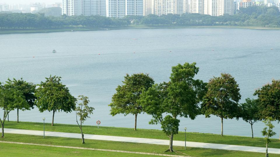
Every nation allocates green space for recreation, but Singapore is undertaking the mega-project of all time: Park connectors that encircle the entire city so sports enthusiasts can just keep going! The idea, proposed in 1987 when Singapore planners sought creative ideas for maximising green space in this land-scarce city, included repurposing drainage ditches, abandoned rail track and other neglected strips of land and turning them into what’s now 200 km of pathway for recreational users. There’s no traffic. No vehicles, in fact. Just kilometer after kilometer of scenic paths that will ultimately encircle the city like a warm embrace.
Pang Sua
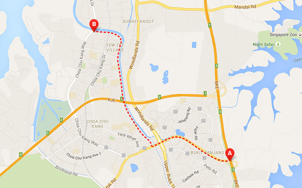
Directions: Pang Sua is part of the Western Adventure Loop linking nature reserves and parks. Begin your run at Zhenghua Park; follow the Bukit Panjang Road along the Pang Sua Canal, ending at Choa Chu Kang Way.
Distance: 6 km
About the route: Two dramatic butterfly gardens delight runners as they traverse this rehabilitated recreational throughway where runners also glimpse birds and other winged things, so you get a nature fix and a workout.
Get there by public transport: Catch the MRT to Choa Chu Kang Station and Bus 67 or 190 to Junction 10.
If you drive: There’s a carpark at Junction 10 or grab extra exercise by leaving your car at the Block 160A, Jalan Teck Whye, multi-storey car park.
Highlights: After being given a complete makeover by the ABC Waters Programme, this park has become a role model for “softscaping and naturalisation” all along its borders. A section of the canal became a rock stream; runners can take breaks on the viewing deck to observe the transformation.
Northern Explorer
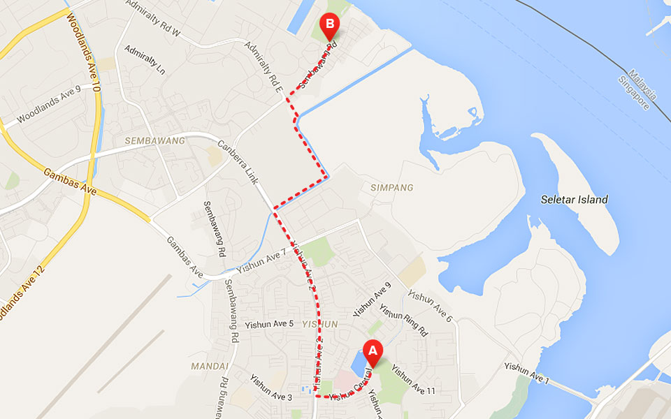
Directions: Start at Yishun Park, run through the Khatib Bongsu Park Connector followed by the Simpang Kiri Park Connector to arrive at Sembawang Park.
Distance: 25 km
About the route: Made ready for runners in late 2010, the Northern Explorer loop costs S$19 million to construct!
Get there by public transport: Take MRT to the Yishun Station. Walk to the Yishun Bus Interchange and board Bus 812 that stops at Safra Yishun Country Club. This connector is situated beside the Club, so it’s hard to miss.
If you drive: Leave your car at the Safra Yishun Country Club carpark.
Highlights: Called by runners and city planners alike a “true urban challenge”, this circuit will take you into the epicentres of several neighbourhoods, including Yishun and Sembawang.
Coast to Coast
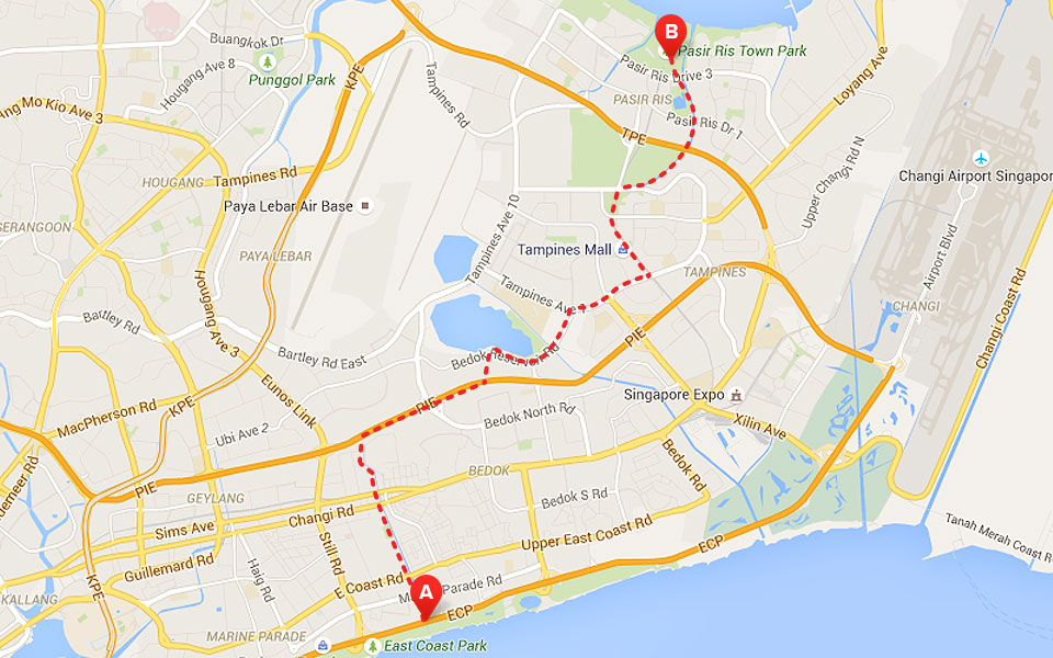
Directions: This popular circuit starts at East Coast Park. Take the Siglap Park Connector to Bedok Reservoir Park and link next to the Tampines Park Connector that lands you at Pasir Ris Park.
Distance: 13.5 km
About the route: It’s easy to see why this has become one of Singapore’s most popular circuits: The scenery is breathtaking. Spot dragon boaters and canoe paddlers enjoying the Bedok Reservoir as you run.
Get there by public transport: Ride the MRT to the Bedok Station. Catch Bus 197 to Marine Parade Road. It’s just a short walk to East Coast Park.
If you drive: The East Coast Park Carpark C4 is your best bet. Reach the destination from East Coast Park Service Road.
Highlights: Don’t confuse this circuit with what’s called “The Coastal Route” the runs from Changi Beach Park to the Coastal Park Connector and finishes at East Coast Park. You’ll know you’re on the wrong trail if you hear jet engines, since East Coast Park is close enough to Changi Airport to override your ear buds.
Khatib Bongsu
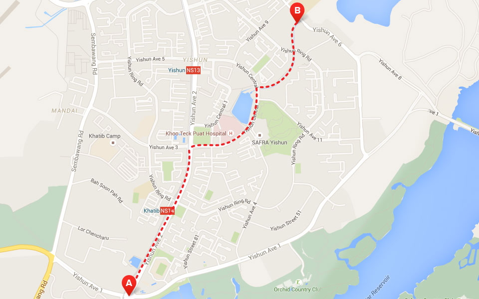
Directions: Start at the junction of Yishun Avenue 1 and Avenue 2, located in the Lower Seletar Reservoir. Run along Yishun Central and Yishun Ring Road. The short connector ends at Yishun Avenue 6.
Distance: 3.6 km
About the route: If this short, scenic stretch of road isn’t enough of a challenge, you can attempt the “Canopy Walk” at Yishun Park where five-metre-high obstacles require you to channel your inner monkey.
Get there by public transport: Exit the Khatib MRT station and follow the clever sidewalk signs to the start of this connector path. Signage is so great, you can’t get lost.
If you drive: Once you’re on Yishun Avenue 2, take a side road to the Blocks 788/785 carpark.
Highlights: Even if you only see it once, check out Bottle Tree Park where these unique trees coexist nicely with Grass Trees. Don’t be surprised if this park reminds you of Australia, because it’s supposed to!
Woodlands Waterfront Park
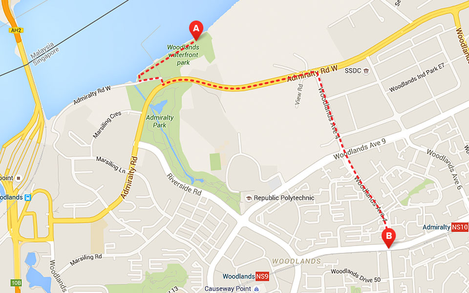
Directions: This 11-hectare park at the Woodlands Waterfront offers exceptional sea views, whether you run through the park or add the Admiralty Road Connector to your route.
Distance: The waterfront promenade is 1.5 km long; the Admiralty connector adds another 1.3km.
About the route: If you like heights, this coastal park offers high vantage points and panoramas, so you get a bit of an elevation boost. Dedicated jogging areas are prominently marked so you won’t get lost.
Get there by public transport: Take Bus 856 from either the Yishun or Woodlands Interchanges.
If you drive: Use the Admiralty West Carpark.
Highlights: This connector circuit gives runners spectacular views of the sea, and access to adventurous and challenging trails identified by a great network of signs. Don’t stop to feed the monkeys, however, or your run could be cut short.
Pandan Reservoir
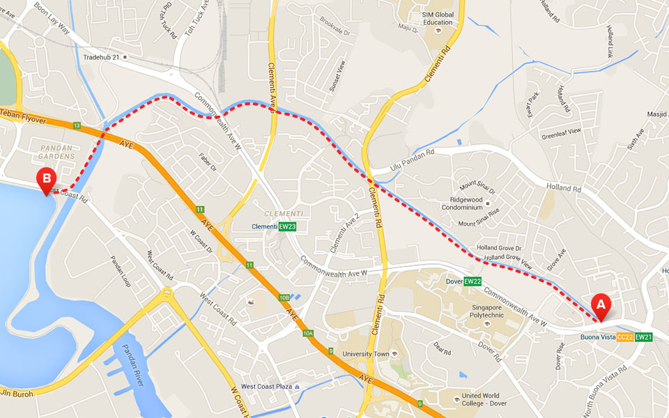
Directions: Complete this circuit by travelling along the Ulu Pandan Park Connector to Pandan reservoir.
Distance: 6 km
About the route: Watch out for bicyclers; this is a popular route for bikers. Once you start running, you’ll spot birds and dragonflies and enjoy cool breezes along this leg of the Western Adventure Loop.
Get there by public transport: Take the MRT to the Buona Vista Station. Alternately, take the Jurong East Interchange (NS1/EW24) and continue on via Busses 78, 78A or 143.
If you drive: Use West Coast Road to access the Teban Gardens residential neighbourhood where there are several carparks from which to choose.
Highlights: Once you cross Clementi Road, spot what’s left of abandoned railway bridges. Some call them historic. Others call them blight. Consider adding the Ulu Pandan Park Connector Bridge, an elevated stretch popular with bikers.
Jurong Lake Park
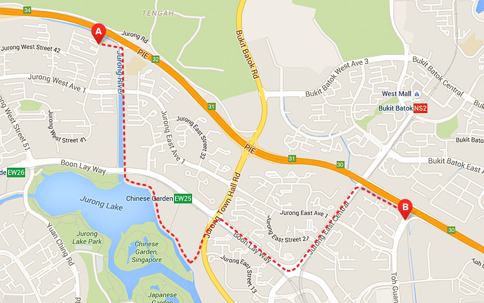
Directions: The Jurong Lake Park Connector starts at the Pan-Island Expressway (in the Jurong West Street 42 Estates neighbourhood) and takes runners alongside the Ayer-Rajah Expressway, ending at Toh Guan Road.
Distance: 9.4 km
About the route: There are a few twists and turns on this linear connector. Enjoy acres of plants, flowers and trees along the way. Run past the row of factories between Enterprise Road and Jalan Boon Lay to catch whiffs of baked biscuits as they come from the oven from the the Khong Guan Factory.
Get there by public transport: Get off at the Boon Lay MRT station if you want to start your run at Jurong Central Park.
If you drive: If you can’t find parking along Yuan Ching Road, stow your car at the Taman Jurong Shopping Centre, 399 Yung Sheng Road, and do a little shopping as well.
Highlights: Unique landmarks adjacent to this connector path are the Chinese and Japanese Gardens overlooking the Jurong Lake. This boardwalk is a biodiversity Mecca, but don’t let the, birds, amphibians and butterflies distract if you’re running a personal best.
Mandai Park Connector
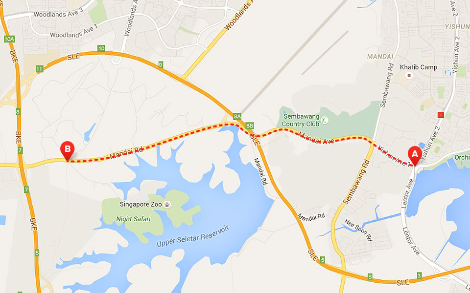
Directions: The Mandai Park Connector starting point is located at Lentor Avenue. The remainder of the route encompasses these streets: Yushin Avenue 1 and Mandai Avenue (becomes Mandai Road), at which point the route ends at the Mandai Lake Road Junction. Signs will help point the way.
Distance: 5 km
About the route: As part of the Central Catchment Nature Reserve, this beautiful run guides you through the Mandai Connector, Ulu Sembawang connector and ultimately to the Khatib Bonsu Park Connector. Part of this connector was established in 1855, so it has more history than most!
Get there by public transport: Lots of buses get you here: Bus 39, 85, 85#, 851, 852, 853, 853#, 854, 855, 857, 858, 965 and 969. The Khatib MRT station is a bit further from the route’s starting point.
If you drive: Your best parking bet is the Upper Seletar Reservoir Park Carpark.
Highlights: This Heritage Road connector is a favourite of the wheelchair crowd! It was once a popular carriageway now regaled with Rain trees featuring huge canopies and lots of flowers and plants.
Zhenghua Park
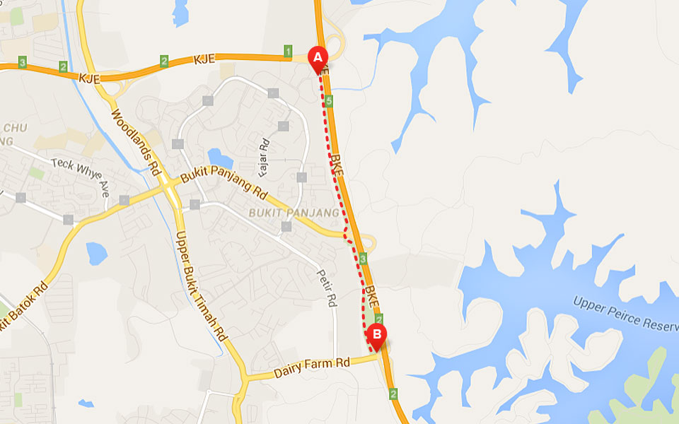
Directions: Zhenghua Park is bounded by the Bukit Timah Expressway, BKE Slip Road to the Kranji Expressway and Dairy Farm road. This connector links the Bukit Pangang Park Connector to the Bukit Timah Nature Reserve.
Distance: 2.5 km
About the route: This park spans 13.5 hectares so you can either run laps at the park or continue on through any of the aforementioned connectors. Along the way, 20 species of trees line the route, including a huge rubber tree presence.
Get there by public transport: Exit either the Bukit Gombak or Segar LRT Stations and follow the signs to the park and connectors. Alternately, Buses 700, 700A or 966 will get you much closer to the park.
If you drive: Try adjacent school lots (Beacon Primary and Greenridge Secondary) or carparks along Panjang Ring Road. If you have no luck, leave your car at the Fajar Shopping Center at 445 Fajar Road.
Highlights: Completed in 2002, the park’s linear connector was inserted into green space that served as the PUB pipeline reserve. Fitness stations and other amenities can be found within the park itself.
Great Singapore Park Connector Network
Singapore’s park and recreation planners had hoped to be finished by 2015 but resources and circumstances have caused them to move the goal 2017. Our question to you: Will you be eager to run the entire circuit once it’s complete or will you wait for the inevitable Singapore Park Connector Marathon?


