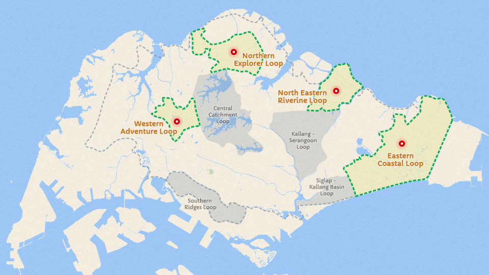
Ever think of conquering Singapore Island by running around it? You can do so using the Singapore’s Park Connector Network which is a round route of about 150km. The route will go through 4 of the current Park Connector Loops and two of the upcoming Loops – Southern Ridges Loop and Siglap Kallang Basin Loop.
Park connectors bring people closer to nature and motivate them to exercise, each loop has a distinct personality of their own. Various heartland parks are linked via park connectors, which are footpaths maintained by NParks and are lit at night. You can literally connect Singapore together with all the park networks.
The current Park Connector Network has a combined distance of 113km, and cost a whopping S$101 million to construct with 4 more loops to be completed by 2017 to bring the total distance to 300km. The best part is that they are all open for you to explore for free!
North Eastern Riverine Loop
This is the newest loop that was launched early last year. 80% of the route takes place along the waterways and reservoirs of Singapore, meaning that there will be plenty of scenic sites and wildlife for you to take in.
The North Eastern Riverine Loop links Punggol Park, Punggol Waterway Park and Sengkang Riverside Park for around 26km. Running along the outer perimeter of the loop (skipping Punggol Waterway Park) will be around 17km, perfect for long runs leading up to half marathons.
Approximate distance: 26km (or 17km along outer perimeter)
Nearest MRT Stations: Buangkok, Sengkang
Cost of construction: S$57 million
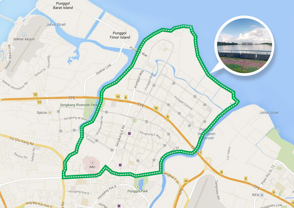
Things to check out along the North Eastern Riverine Loop:
- Running on the 2.8km stretch of easy dirt terrain with beautiful scenery at Punggol Promenade Nature Walk.
- Well-paved asphalt roads for majority of the loop.
- Wide open area, perfect for running in breezy evenings.
Western Adventure Loop
The Western Adventure Loop consists of rugged, undulating tracks linking 8 nature parks of western Singapore such as the Bukit Batok Nature Park, Dairy Farm Nature Park and Zhenghua Park through 9 park connectors, including the Pang Sua Park Connector with 2 butterfly gardens.
The loop is recommended for those who love nature and the outdoors as you will be running through various greenery trails. With Bukit Timah Nature Reserve closed, runners will be advised to run along Dairy Farm Nature Park instead.
As some stretches of the loop are used for off-road cycling, use the Western Adventure Park Connector Walking Trail to plot your runs instead. The total distance for this trail will be around 12km in length. Grab your trail running shoes and get ready to tackle some slopes and trails on this loop!
Approximate distance: 20km (12km for WAPCN Walking Trail)
Nearest MRT Station: Choa Chu Kang, Bukit Gombak, Bukit Batok
Cost of construction: S$10 million
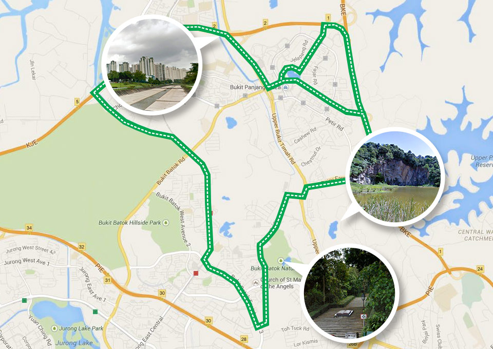
Things to check out along the Western Adventure Loop:
- Singapore Quarry is a tranquil rest spot at the end of Dairy Farm Nature Park.
- The Pang Sua Park Connector is one of the more scenic portions of the loop, with wide open spaces in the middle of the heartland.
- Undulating trail at Bukit Batok Nature Park with beautifully calm ambience and another serene quarry pool dubbed Little Guilin for its picturesque lake and craggy hill.
Northern Explorer Loop
This loop is different from the other loops, in that it goes through plenty of urban scenery linking the towns of Sembawang, Woodlands and Yishun and connects 11 parks and nature sites such as Sembawang Park, Admiralty Park and Woodlands Town Garden. There are some green scenery in Woodlands Town Garden and Woodlands Waterfront.
Approximate distance: 25km
Nearest MRT Stations: Woodlands, Admiralty, Sembawang, Yishun
Cost of construction: S$19 million
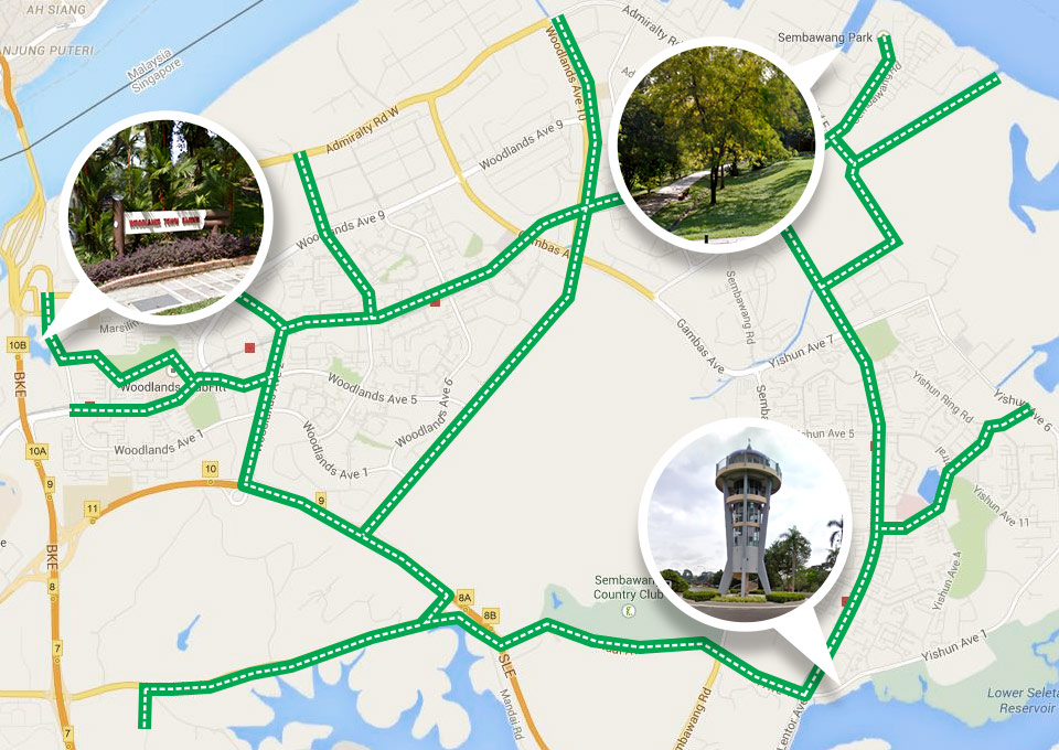
Things to check out along the Northern Explorer Loop:
- Lower Seletar Reservoir Park has a quiet atmosphere. Climb up the “Rocket Tower” for a wonderful view of the Seletar Reservoir!
- Woodlands Town Park has 13 beautiful pavilions built in traditional Chinese and Malay architectural styles.
- Sembawang Park is richly intertwined with Singapore’s history, with restored old pathways from the British Occupation. It also contains one of the few remaining natural beaches of Singapore.
- Enjoy the view of the bustling Straits of Johor from the Waterfront Promendae at the Woodlands Waterfront and the kampong vibe at the Ulu Sembawang Park Connector.
Eastern Coastal Loop
This is the biggest and longest loop in Singapore. It links the 4 major parks in eastern Singapore, which are East Coast Park, Pasir Ris Park, Changi Beach Park and Bedok Reservoir Park through 7 park connectors, such as the Siglap Park Connector and the Tampines Park Connector.
At 42km in length, it is more or less marathon-length, and will be perfect training for marathon and ultramarathon runners!
3 of 5 great places to run and eat in Singapore are within or near this loop, so don’t fret if you’re feeling hungry after your run!
Approximate distance: 42km
Cost of construction: S$22 million
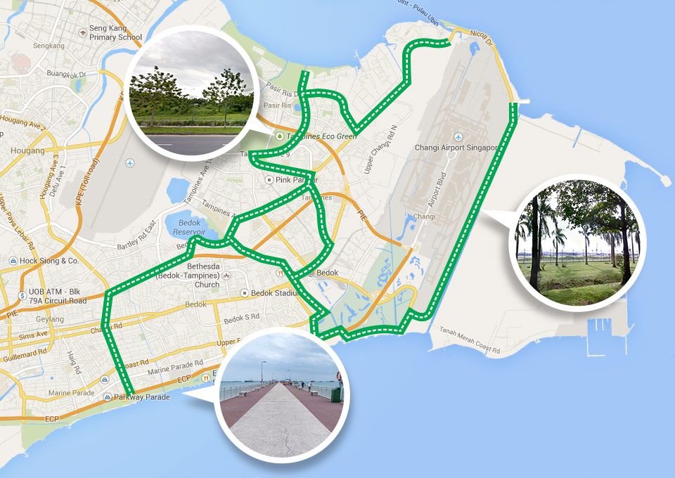
Things to check out along the Eastern Coastal Loop:
- Explore Bedok Jetty, which is popular with fishers. Bedok Jetty is also Singapore’s longest jetty!
- Get to see planes taking off when you run along the 7km stretch at the Coastal Park Connector.
- Tampines Eco Green is an interesting eco-friendly park, where signs, benches, and bird-hides are constructed from recycled or eco-friendly materials.
- Visit the mangrove boardwalk and the three-storey bird-watching tower at Pasir Risk Park.
- Check out the heritage trees in Changi (see if you can identify all 9 of them!) and the cable ski along with other watersports at East Coast Park too.
Look Forward to 300km of Beautiful Scenery to Explore in 2017!
You don’t have to finish these park connector loops in a day. Take your time to explore them and find ways to incorporate them into your runs.
Since these park networks are maintained by NParks, please remember to treat these places of nature responsibly: Don’t litter, and don’t disturb the wildlife (taking photos are encouraged though)!
There are 4 more planned Park Connector Loops under construction that will be built by 2017: the Kallang-Serangoon Loop, the Central Catchment Loop, the Southern Ridges Loop, and the Siglap-Kallang Basin Loop.
Nature lovers will enjoy the Central Catchment Loop as almost 75% of the track will be in nature surroundings that will follow the circumference of the central catchment nature reserve, where popular reservoirs like the MacRitchie and Peirce reservoirs are situated.
The Southern Ridges Loop will incorporate the current 10km Southern Ridges trail that links parks such as Mount Faber Park, Labrador Nature Reserve and the Kent Ridge Park. Runners will have the opportunity to run across Henderson Waves, Singapore’s highest pedestrian bridge that connect Telok Blangah Hill Park to Mount Faber Park.
The Kallang – Serangoon Loop will connect runners with at least half of the track via a canal from Bishan Park, down the Kallang Park Connector and the Pelton Canal Park Connector, passing by areas such as Hougang Avenue, Balam Park and Serangoon to finally reach Ang Mo Kio Town Garden West.
When completed, there will be an astounding network of 300km of these “green corridors” for all to enjoy. We can’t wait to explore them when they’re open!


